The Ancient Kingdom of Urartu
August 2, 2012By: Shahan Goenjian
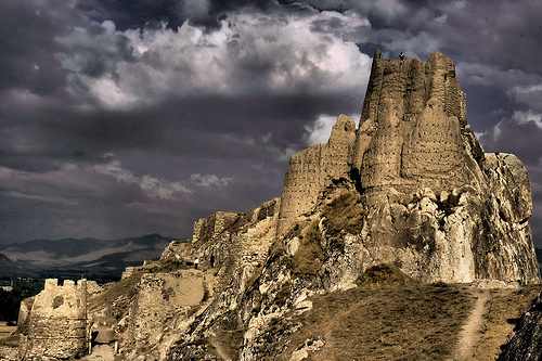
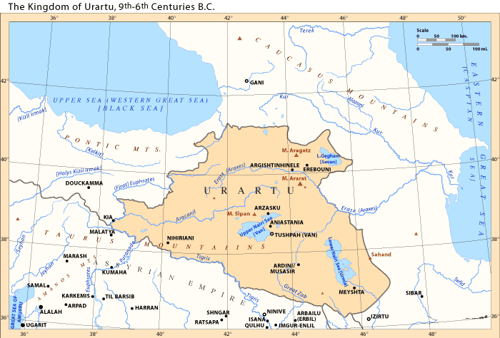
The Kingdom of Urartu came into existence in the 13th Century BCE. It was formed by a collection of tribes and countries as political-military network that inhabited the area around Lake Van in the Armenian Highlands, North of the Mesopotamian region. Its capital was Tushpa-Van, a city protected by the citadel of Van, on the east coast of Lake Van. The three most important cities to the kingdom, besides Tushpa-Van, were Erebuni, Argishtihinili, and Musasir. Archaeological data from this region is sparse and most of its history has been gathered from Ancient Assyrian artifacts. For this reason, the most detailed history of the Kingdom of Urartu covers the period in which Urartu and Assyria clashed for dominance in the 9th and 8th centuries BCE. The Kingdom of Urartu fell in the early 6th century BCE.
The land which Urartu governed over was composed of many different groups of peoples. From examples of Urartian tablature, it is known that the people of Urartu referred to themselves as “Biainili.” Urartian texts have shown that the kings of Urartu often called themselves the “king of the land of Biaini,” and in Assyrian texts, Urartian kings were labeled the “king of the land of Nairi.” The land of Nairi/Biaini is known to be the land surrounding Lake Van (or the Sea of Nairi). Hebrew texts referred to Urartu as the “Kingdom of Ararat.” Historians believe that over the entire span of the kingdom’s life, people of Mitanni, Khurry, Khaldea, and Hittite blood to have lived among the Urartians during its early history. Its later inhabitants, those that eventually brought the kingdom to its end, were the Phrygians, Moskes, Armens, Scythians, Alans, and Cimmerians. Some of these groups were brought to Urartu as prisoners of conquest and were often put to work in labor forces. Others, like the Cimmerians, who were nomads, Moskes, and Alans, invaded the land from the north around 580 BCE.
Most of the knowledge regarding Urartu comes from a series of clay tablets found among ancient Assyrian ruins. They hold the reports from Assyrian intelligence agents that were sent to various cities in Urartu. These clay tablets give us a record of history for a period of time around 714 BCE. During this time, the Kingdom of Urartu was at its height in dominance, but the Assyrian Kingdom had recently regained its power under the rule of Sargon II. By studying historical records of the conflicts that occurred between Urartu and her neighbors, one can estimate the limits to where Urartu’s borders extended. To the North, Urartu extended near the Black Sea and Caucus Mountains. To the East, the region of Lake Urmia. To the West, it consumed the Taurus Mountains and it shared an alliance and a border with the Mediterranean coastal country of Tabal. And to the South, the Zagros Mountains which separated the kingdom from Assyria.
The land that Urartu controlled was mountainous and densely forested. There are several rivers and tributaries that run through the land as well, like the Araxes, Euphrates, Tigris, and Kura. There are also three large lakes, Lake Van, Sevan, and Urmia. Lake Van and Urmia are salt-water lakes so they provided ample salt and a diverse ecosystem for its regions. In the many valleys in the land, cotton, mulberry trees, grapevines, apricots (the national fruit of Armenia), peaches, pomegranate, other fruit trees, rice, and tobacco were grown. Certain towns focused on forestry and raising cattle and horses; kings and armies often used their forests as hunting grounds and trained horses for cavalry and chariots. Due the land’s mountainous features, mining provide an abundant amounts of minerals, crystals, naphtha, copper, salt, iron, lead, silver, gold, borax, arsenic, and semi-precious stones. This factor combined with the possibility of Hittite ancestry lent to the excellent metal-working abilities and charioteering of the Urartians.
Because Urartu was so mountainous, travel between towns and cities was not easy. The winters’ cold weather and snowfall made travel even more difficult. Towns were separated into districts which were governed by governors chosen by the king, or viceroys after Rusa I. However, the mountains gave Urartu military advantages. Towns were not only safe from invading forces that would have a difficult time passing through the mountains, but many were also protected by fortresses. These fortresses also kept watch over the many trade routes that ran through the Urartu. And in the 9th and 8th century BCE, Urartu controlled trade routes that led to the Mediterranean. These trade routes proved to be an extremely important economic asset to the kingdom and elevated its dominance in the Near East during that time period.
The Kingdom of Urartu was at one point the largest and most dominant state in the Mesopotamian region. It was not a single nation but rather a unified government that controlled and protected the various independent districts and peoples of its land. By the kingdom’s end in 585 BCE, the nomadic Cimmerians from the North, the Phrygians from the West, and the Scythians from the East had invaded Urartu, mingled into the highlands, and mixed the Bianilini and the Armens, who were known to have occupied the area west of Lake Van. After the fall of Urartu, these new peoples subsequently formed the first Armenian kingdom.

